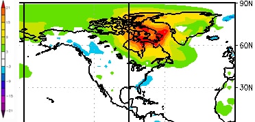
While world media have been distracted by cold temperatures in Europe (December averages in the U.K. were 5.2°C [9.4°F] below normal), a vast pocket over northeastern Canada has been hitting heights that were not just unprecedented but, until this year, unimaginable.
As Bob Henson reports at the NCAR & UCAR Currents, the Canadian low Arctic has been unseasonably, unreasonably balmy, with the largest anomaly rising to 21°C [37.8°F] above normal. Hudson Bay and the waters around Baffin Island remained open well beyond usual, suggesting that the risk for an extraordinarily low summer ice season is built into the works. (If you look at this map, from Bremen University, you see that even the North Pole was unconvincingly frozen by Jan. 11 of this year.)
Henson looks particularly at the community of Coral Harbour, on the northwest corner of Hudson Bay in Nunavut, where typical January temperatures range from a bone-chilling low of –34°C (–29.2°F) to teeth-chattering “high” of -26°C (–14.8°F). This year, Environment Canada reported that in the first 12 days:
- Coral Harbour went 11 days without getting down to its average daily high.
- On Jan. 6, the low temperature was –3.7°C (25.3°F) – that’s 30°C (54°F) above average.
- On both the 5th and 6th, Coral Harbor inched above the freezing mark. Before this year, temperatures above 0°C (32°F) had never been recorded in the entire three months of January, February, and March.
Fans of this kind of weather trivia (which is to say, courageous people who don’t mind spending the odd sleepless night considering the trajectory of Earth’s changing climate) should shuffle on over to Lou Grinzo’s blog, The Cost of Energy, and look especially to Lou’s Quick Graphs, a great page that pulls together a host of useful and interesting scientific sources, all of which tend to argue that we’re in a heap of trouble.
Subscribe to our newsletter
Stay up to date with DeSmog news and alerts


